About NZ RoadAtlas | New Zealand Road Atlas with Offline GPS Navigation
Discover New Zealand with NZ Road Atlas, the app that turns your iPhone or iPad into a real-time GPS navigation tool with offline maps. NZ Road Atlas is the ideal travel navigation app for everything from camping,...
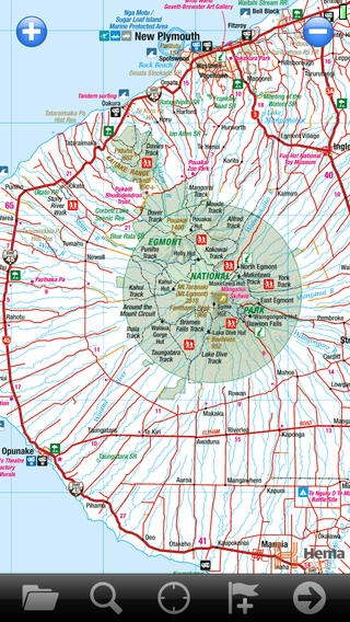
Discover New Zealand with NZ Road Atlas, the app that turns your iPhone or iPad into a real-time GPS navigation tool with offline maps. NZ Road Atlas is the ideal travel navigation app for everything from camping, off-road 4x4, caravan and motorhome touring, as well tramping and cycling throughout New Zealand. NZ Road Atlas offers seamless north and south island maps of New Zealand as well as a map of the country in its entirety. With the app you can track your exact location on the map as well as navigate, plot and save your route. The maps are already preloaded with the app, which means you don t need any cellular coverage for navigation and to know exactly where you are at all times on your iPad* or iPhone. NZ Road Atlas is the perfect GPS navigation tool for outdoor adventurers, tourers and general tourists, with everything from tourist routes, motorhome parks, dump stations and campsites to adventure activities such as bungy jumping all pinpointed on the maps with helpful symbols. NZ Road Atlas allows travellers to navigate their way around Aotearoa and experience the best things the country has to offer, everything from camping, caravan and motorhome touring, off-road 4x4, tramping, cycling covered on each map. GPS navigation made easy Moving map display Displays and records breadcrumb trail as you move Simple creation and editing of waypoints and routes Placename search Displays Position, Course, Speed, Heading, Altitude and Averages In-built Wikipedia search function for nearby locations Name marks as locations of interest eg Great tramping trail Use the Digital Map Shop to purchase more specific maps Screen orientation lock option (portrait or landscape) App will continue to track and store data in the background while using other iPad or iPhone features Complete coverage North island map South island map New Zealand Super map No instructions needed NZ Road Atlas uses simple and user-friendly layout and icons Intuitive map rollover when scrolling and zooming in and out for seamless navigation Offline maps Know where you are offline on your iPhone and iPad with the app Preloaded offline maps means no 3G or WiFi coverage is needed to view entire maps on your iPhone or iPad Navigation for touring Campsites Motorhome & caravan parks Dump stations Roadside rest areas Te Araroa Trail Inland Scenic Tourism Route Southern Scenic Tourism Route Twin Coast Tourist Route Thermal Explorer Tourist Route Pacific Coast Tourist Route Surf Highway 45 Forgotten World Tourist Route Classic New Zealand Wine Trail The Great Alpine Highway Navigation for adventure activities Bungy Jumping Caving Diving/Snorkelling Dolphin Watching Fishing 4WD/ 4x4 Jet Boating Hang Gliding Kayaking/Canoeing Movie Set Location Mountain Biking Skydiving Scenic Flights Skiing Surfing Thermal Area Tramping & Hiking Whitewater Rafting Winery Share your off-road adventure Email tracks, routes and marks (such as camping spots, tramping, cycling or touring routes and trails) to your friends and family to share your off-road adventure (in open GPX format) *Although you do not need a SIM Card installed or cellular coverage to utilise the GPS tracking functions on iPad for the app, a 3G-enabled iPad (as opposed to a WiFi only iPad) is necessary to discover and track your location. A WiFi-only iPad does not contain the in-built GPS that a 3G iPad does, however external Bluetooth GPS receivers can be purchased for use with a WiFi-only iPad. Battery Use Disclaimer: Continued use of GPS tracking can dramatically decrease battery life.
Requires iOS 4.3 or later. Compatible with iPhone, iPad, and iPod touch.
Previous Versions
Here you can find the changelog of NZ RoadAtlas | New Zealand Road Atlas with Offline GPS Navigation since it was posted on our website on 2016-09-27 19:53:35.
The latest version is 1.6.0 and it was updated on 2024-04-22 19:22:03. See below the changes in each version.
NZ RoadAtlas | New Zealand Road Atlas with Offline GPS Navigation version 1.6.0
Updated At: 2012-02-08
Disclaimer
Official App Store Link
We do not host NZ RoadAtlas | New Zealand Road Atlas with Offline GPS Navigation on our servers. We did not scan it for viruses, adware, spyware or other type of malware. This app is hosted by Apple and passed their terms and conditions to be listed there. We recommend caution when installing it.
The App Store link for NZ RoadAtlas | New Zealand Road Atlas with Offline GPS Navigation is provided to you by apps112.com without any warranties, representations or guarantees of any kind, so access it at your own risk.
If you have questions regarding this particular app contact the publisher directly. For questions about the functionalities of apps112.com contact us.